
The Orkney Image Library
Help us get organised! If we haven't correctly identified which area this picture is best listed under, please select it below and click Done!
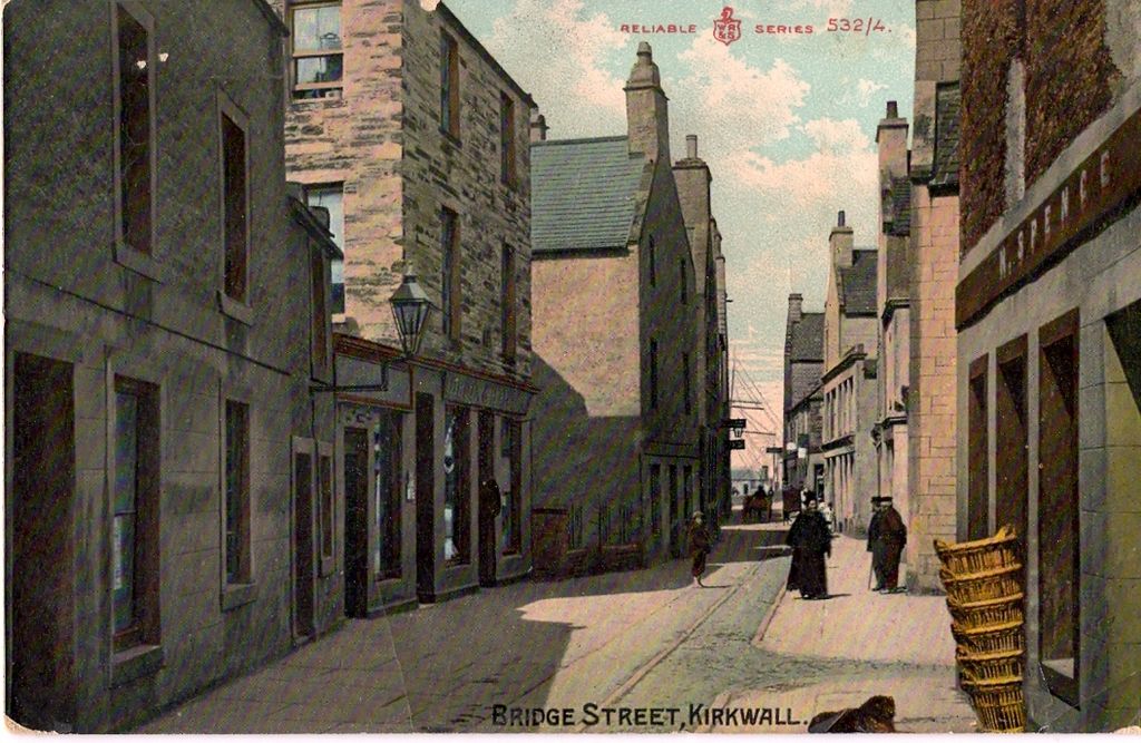
Date is an estimate. Nichol Spence is first on the right and it was a great shop for bits and pieces. When did it first open?
 View Large Version
Picture added on 10 April 2007
I've just noticed for the first time the curious curve in the building line on the left side of the street. I wonder if it is a reflection of the long-vanished shape of the churchyard of St Olaf's that stood opposite, or if this was an open space on front of the church. Or maybe it is just the shape of the Peerie Sea's shoreline when houses were first put up along it.
Added by Paul Sutherland on 12 April 2007
The Papdale Burn flowed pretty much down the centre of the street so the houses and the curve reflects streams route.
Added by Graham Macdonald on 14 April 2007
No, the Papdale Burn flowed (and still does flow in a culvert) along what is now Bridge Street Wynd, taking a sharp left on front of Nicolson's/ Lows' office, then under Bridge Street at Leonards, then down the Burn Lane as shown in picture #360 and picture #355. It then joined up with the Long Gutter (now Mounthooly Lane), before turning right and heading for the Peerie Sea.
Added by Paul Sutherland on 16 April 2007
Hmm now you've got me wondering about the route. I wonder if Burn lane was the later medieval route? Raymond Lamb the county archaeologist in the 1980s found evidence in some digs in the area that it took the route down Bridge Street, but was later changed to service mills and such like.
Added by Graham Macdonald on 17 April 2007
Interesting puzzle Paul, this is the best online map of old Kirkwall, no clues there though: www.nls.uk/maps/early/towns.cfm?id=1914
There's a series of Kirkwall maps in Hossack's 'Kirkwall in the Orkneys' not sure if any show the Kirk and grounds.
Did the Papdale Burn originally terminate on the shore at the back of the 'old men's hut'? I think the 1970's Burnmouth Road culvert project diverted it into the Peerie Sea to act as a flood reservoir.
Added by Karl Cooper on 17 April 2007
I must confess my ignorance of the mediaeval period and the archaeological evidence. You've got me wondering about that sharp turn in the burn in Bridge Street Wynd though. Might it have been a man-made diversion to stop it flowing through the churchyard or to provide a defensive feature at the then southern boundary of the town/village? I don't know. But if it was, we're surely speaking about the very beginnings of Kirkwall the best part of a thousand years ago. There's so much waiting to be discovered under the Garden's site and the oil depot. I just hope the powers that be insist on it being excavated before any redevelopment.
Added by Paul Sutherland on 17 April 2007
An even older map here + lengthy paper:
www.rcahms.gov.uk/papar/orkney7.html
www.rcahms.gov.uk/papar/orkney7.html
Added by Karl Cooper on 18 April 2007
Newspaper reports of the Proclamation of King Edward VII(see picture #2942) describe the procession as going down Queen Street then through the Burn Lane to Albert Street, so it seems the Bridge Street Wynd part of the burn's route was also called the Burn lane, not just the bit below the street.
Added by Paul Sutherland on 30 April 2007
I've come across the answer to Kirkwallian's question in a 1960s Orkney guide book. An advert for Nicol Spence & Son says: "Established 1867".
<< back
Added by Paul Sutherland on 23 August 2007
Kirkwall


