The Orkney Image Library
Help us get organised! If we haven't correctly identified which area this picture is best listed under, please select it below and click Done!
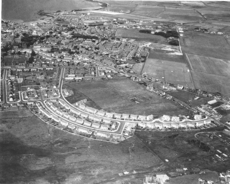
Quoybanks.
The Quoybanks area in 1962.
Photo courtesy of Sylvia Moar.
[I like the bonny white pavements, and that you can see where the Quoybanks farm buildings were. Note no Summerdale Drive or Craigie Crescent, and the reamins of the camp where Royal Oak Road is now. The Kirkwall Primary School is there, but with no tennis courts - Steven]
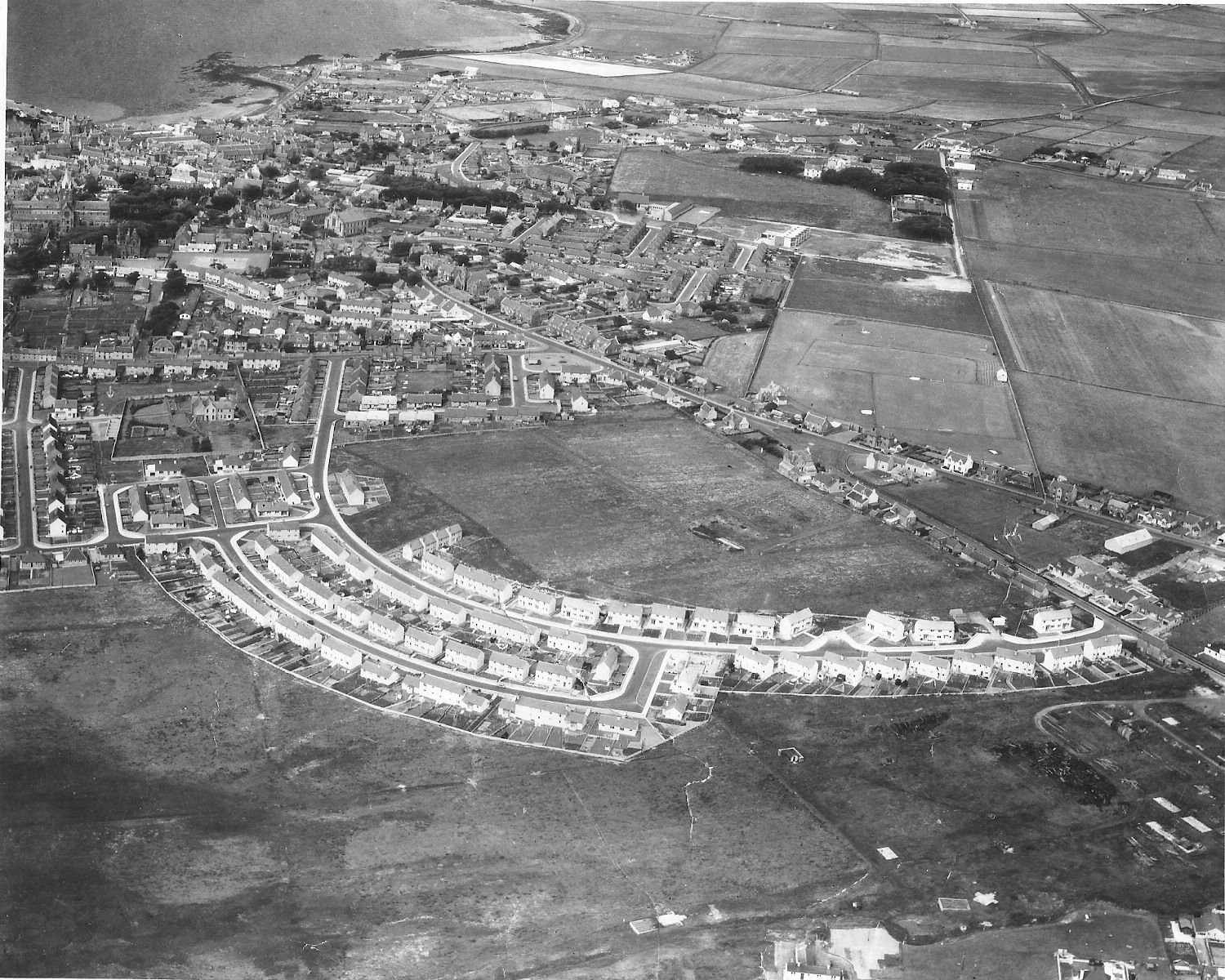 View Large Version
Picture added on 23 November 2011 at 16:25
Bruce, you'll find the farm on this map of Kirkwall from 1879
Added by Karl Cooper on 23 November 2011
The Quoybanks farm buildings would have been where the Summerdale Drive garages are now. Where was the farm house and who owned Quoybanks farm?
Added by Ian Tait on 23 November 2011
Magnificent photo....gives a real insight into how the town has developed.
[It's doubled in size in my lifetime - in 50 years the rest of Orkney will be empty! -Steven]
[It's doubled in size in my lifetime - in 50 years the rest of Orkney will be empty! -Steven]
Added by Geoff Linnitt on 23 November 2011
Ah yes, I was a junction out, I was looking at the Craigie Crescent junction thinking it was Quoybanks Place.
I notice the old car entrance to the Biggy. I had forgot about that and it's not that long since the Link Road geed in.
Thanks for the link to the old map of Kirkwall Karl. Interesting to note that Clay Loan and Union Street is the opposite way around from what it is now!
I notice the old car entrance to the Biggy. I had forgot about that and it's not that long since the Link Road geed in.
Thanks for the link to the old map of Kirkwall Karl. Interesting to note that Clay Loan and Union Street is the opposite way around from what it is now!
Added by Bruce Moar on 24 November 2011
We moved to 20 Quoybanks in 1957.
The last few courses of stones were still there from ruins then. These would be towards the Holm Road side of the field behind our house, about where these sheds? are in this picture. We used to play in them.
The last few courses of stones were still there from ruins then. These would be towards the Holm Road side of the field behind our house, about where these sheds? are in this picture. We used to play in them.
Added by Fred Grieve on 24 November 2011
With reference to the Link Road, I think it went in 20 years ago. Time flies!
[Great picture Sylvia, thanks for letting Sandy submit it - Steven]
[Great picture Sylvia, thanks for letting Sandy submit it - Steven]
Added by Sylvia Moar on 25 November 2011
Great photo Sandy, what was it taken from exactly ?
Anonymous comment added on 25 November 2011
I don't know much about this photo. Sylvia told me she had it in a frame. She kindly removed it from the frame and loaned it to me to put on here. I will ask her if she has any more information.
Added by Sandy Windwick on 26 November 2011
On the back of the photo it says:
AERO FILMS AND AERO PICTORIAL LTD
No A107481
Sylvia says it was on display in The Orcadian office window, when it was in Victoria Street, and she bought it for seven shillings and sixpence.
AERO FILMS AND AERO PICTORIAL LTD
No A107481
Sylvia says it was on display in The Orcadian office window, when it was in Victoria Street, and she bought it for seven shillings and sixpence.
Added by Sandy Windwick on 26 November 2011
Does anyone know who farmed Quoybanks Farm?
Added by Sandy Windwick on 26 November 2011
What a brilliant photo. When we moved to Craigie Crescent from Hatston the road from Craigie Cres to Quoybanks wasn't finished. Used to walk through the mud with a note for ten fags for mum from the Quoybanks shop. Good times.
Added by Vince on 28 November 2011
The pavements in the photo are no longer nice and white. They are dirty, broken,sunken,crumbling and dangerous to walk on. At least that's the side that hasn't been nicely replaced with tarmac and new kerb stones.
Added by Neil Johnstone on 28 November 2011
Quoybanks was I think the Parish Glebe, ie the farm provided for the use of the Minister, hence "Kirklands", and why the Manse was built where it was (visible to the left of the picture). I don't know who the tenants were, but I think there are photos of them or their farm workers elsewhere on the site.
Added by Paul Sutherland on 28 November 2011
Neil, I was assured by a councillor two years ago that funding was in place to fix the pavements in the Qoubanks Area. I note it has only been done on the sides where new street lighting has been installed. As you say, the rest of it is just plain dangerous.
Added by Sandy Windwick on 28 November 2011
Quoybanks was farmed by Bichans at the turn of the century and latterly by Ritchies.
Added by Ian Tait on 28 November 2011
I see Aggie Petrie's shop but no Park Loan.You can still see the door step in to the old shop as you walk past.
Added by Northern Rock on 02 December 2011
Other pictures to look at:
Quoybanks farm: picture #6318 and picture #12325.
Quoybanks area: picture #99, picture #366. picture #1487, picture #12243
Quoybanks farm: picture #6318 and picture #12325.
Quoybanks area: picture #99, picture #366. picture #1487, picture #12243
Added by Sandy Windwick on 06 December 2011
Quoybanks appears on an even older map of Kirkwall from 1832 here: http://maps.nls.uk/towns/reform/view/?id=2608, possibly the first surveyed map of the town, Quoybanks must be the one farm within the town that has completely disappeared. Papadale, Glaitness, Soulisquoy, and even Grain at the foot of Wellington Street, still survive in part.
[Who were the Antiburghers, and what was their aim? As our chairman is Leslie Burgher, mercifully they seem to have failed! - Steven]
[Who were the Antiburghers, and what was their aim? As our chairman is Leslie Burgher, mercifully they seem to have failed! - Steven]
Added by Karl Cooper on 07 December 2011
Steven, the Anti-burghers were the branch of the Secession Church that was popular in Orkney - their Kirkwall Meeting House (as they used to call their churches) shown on Karl's map being on the site of what later became the Paterson Kirk. Briefly, the Secession Kirk split from the Established Church of Scotland in the 1730s. It then split into Burgher and Anti-Burgher factions, depending on whether they thought their members could properly take the Burgess oath required to trade in some burghs and which called on them to uphold the church (the question being, was that the Established Church or not?). Each of these factions then split into "Old Lights" and "New Lights". About 1830, the New Light Burghers and New Light Anti-Burghers united to form the United Secession Church, which in 1847 united with the Relief Church to form the United Presbyterians, who in 1900 united with the Free Church to form the United Frees, who united with the Established Church in 1929 to form the present Church of Scotland. Meanwhile the two Old Light factions had united to become the Original Secession Church, who had the Kirk Abune the Hill in Birsay. Bet you're glad you asked!
[I'll hire you as a lawyer any day Paul, just on the basis of the foregoing! - Steven]
[I'll hire you as a lawyer any day Paul, just on the basis of the foregoing! - Steven]
Added by Paul Sutherland on 08 December 2011
And then there were the Burgers, formerly known as the Hamburgers, which split into factions calling themselves the Beefburgers, the Cheeseburgers and the Nutburgers (which embraced the New Lite Nutburgers) but were so strongly opposed by the self-styled 'healthy eating' anti-Burgers, that they reunited under their Burger King and went on to establish Meeting Houses (often erroneously called Eating Houses) in all the major population centres of the world.
Anonymous comment added on 08 December 2011
If the other Paul had been around he would probably have sent them a fairly strongly worded epistle.
Added by Sandy Windwick on 08 December 2011
We were the first family to move in to Quoybanks. We lived at no 10, the rest of the houses were still being built. Can't remember who was at 12, but Harrison the cobbler and Stewart Craigie were in our little bit as well. Round the corner was Sandy Thomson the barber and next to him was the Grieves. We moved there from Hatston I was about 3 or 4 then, there was no tar path only stones.
Added by Sylvia Walker on 09 December 2011
Re Sylvia's comments about families, you've got me thinking, Sylvia. There was another family in the "stepped houses" about then; the McLeods. I used to play with Roddy McLeod first we moved to Quoybanks. They moved away and I seem to remember that they stayed in the top house which was then occupied by Stewart Craigie's family.
As to who lived next to you, I remember the Robertsons (I think he was a baker but not sure) but they weren't the first family. Did Jim Taylor from the GPO not live there briefly before he moved to Pipersquoy?
I remember your Dad used to make scale models in his garden shed that he showed me. They were so immaculate, especially the painting.
Added by Fred Grieve on 11 December 2011
I'm afraid I can't remember who was there before the Robertsons, or Craigies. My Dad used to breed budgies in the shed as well, he won quite a few trophies at the Cage Birds Shows. I'm sure he still has them all in the attic in Laverock road!!
Added by Sylvia Walker on 12 December 2011
I think we moved to No 32 Quoybanks in 1959 and we were first folk in house. Our house was the last one on that side. Must have been built in two phases. Lovely place to grow-up.
Added by Katherine Skea on 17 December 2011
Great picture. The road junctions for Craigie Cres and Quoybanks Place are in place in fact there are private garages in what is now Quoybanks Place. I assume that the Town Council rented the sites to the garage owners.
There are no garages behind Kirklands Road/Pipersquoy where I still have the garage my father built.
The "bumpy" lane from Manse Road towards Pipersquoy is not there, nor are all the houses in Quoybanks Drive. The two shown are Mr & Mrs Kirkness their son Jim was in the police later a Detective. After retirement he was security officer for Royal Bank. And top house is my uncles house - Dan Grieve.
Very confusing area for postie's at Christmas time. We lived in 20 Quoybanks Cres, Dan and family was in Quoybanks Drive and Arnold and family was in 20 Kirklands Road. To make things worse in those formal days Dan was actually Andrew - so two Mr A Grieve's in the same area.
Added by Raymond Grieve on 19 December 2011
Quoybanks farm buildings still stood as a three sided square, open to the east, during the war years. I recall playing there, probably about 1943. The house was occupied by a Hercus family, but I cannot say whether they ran the farm. One of the Hercus boys, until recently, ran the fishing tackle and artists' supplies shop in Bridge Street.
Added by Bill G on 08 October 2012
A great picture, and the way I remember Quoybanks. We lived in 2 Quoybanks Crescent when the house was first built. I remember Sylvia Walker in No 10, Alan Craigie (don't know the number, Stuart Harkus lived at the top of Pipersquoy Road and Johnny MacKay in Earl Thorfinn Street. We were all at school together. Our family moved south in 1964.
Bonfire night was special with a huge bonfire in the field just behind our block between Craigie Crescent and Summerdale Dr.
<< back
Bonfire night was special with a huge bonfire in the field just behind our block between Craigie Crescent and Summerdale Dr.
Added by Ian Finlayson on 14 May 2021
Kirkwall


The close up of the new houses look like its part of a model.
Was the Quoybanks farm buildings where Quoybanks Place is now?
[Looks like they can't be far from the Summerdale Drive/Craigie Crescent junction to me. Bruce. Maybe just a bit north of that. - Steven]